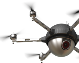
Drone/UAV
Our team of professionals have a proven track record of meeting the needs of our clients.
Drones / UAV
Commun-ET is a strategic consulting firm specializing in these disciplines:
Commun-ET is uniquely positioned as an innovative, certified DBE and CBE company offering “Drone as a Service” (DaaS) provider solutions.
The driving force powering our drone program is based on the collaborative analysis of the mission’s goals and objectives to navigate the space surrounding the regulatory, community, technology and the ultimate usability of data.
Commun-ET has flown missions in areas including Puerto Rico, Florida and the Washington DC Metropolitan Area.
One Stop Shop
One Stop Shop - Drone Services
One Stop Shop - Drone Services
We are a one-stop shop for drone/unmanned aerial vehicles (UAV) services with experience flying for national disasters, transit systems, law enforcement, emergency management agencies and more. Our leadership members are FAA part 107 licensed pilots.
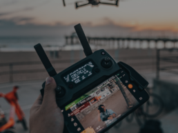
We provide UAV’s with cameras and sensors paired with some of the industry’s top pilots, a DoD certified searchable data storage of aerial data/video, and turn-key expert data analysts.
Our drone mapping services can measure, transmit and reveal insights stored for immediate searchability and exhaustive analysis. Using LIDAR, infrared, orthomosaic and other sensors and technologies, our services quickly capture image data and convert it to 2D, 3D and 4D maps that can be annotated and shared in the cloud to provide informed decision-making in real time.

More than video, it’s communication
More than video, it’s communication
Drone data is more than accessing video. It is data architecture that supports inquiry for the widest possible range of projects from simple verification to complex studies that anticipate future needs. An obvious example is disaster planning and recovery. As is more and better data accessible for major infrastructure decisions, inspections and optimization of budgets.
Commun-ET has worked with many public and private sector organizations to develop comprehensive public engagement processes and understands drone data over time will tell an accurate story of growth, recovery and decision making informed by a more complete opportunity for clear, concise and consistent communications. Reduced cost and efficiency for better, forward thinking data is just the beginning.
Government
Value Across Government
Commun-ET understands its drone programs will be used to optimize the partnership with federal agencies expediting disaster funds and even increasing the number of federal funding sources post disaster. We offer a program to create a partnership with federal agencies to collect the data they will need to work with you effectively on behalf of the people who depend on you